
Idaho Airstrips - Cabin Creek
WARNING! The information presented about the Idaho Airstrips is not intended to replace flight instruction from a competent instructor for flying to or landing at any of the airstrips presented. DO NOT attempt to land at Cabin Creek until you have received instruction on the proper approach. This is a one-way airstrip with no chance of a go-around maneuver. Although much information is presented, it is not sufficient to cover all the hazards associated with these backcountry airstrips.
 Cabin
Creek is located on the north side of Big Creek, about 9-miles west
of the junction of Big Creek and the Middle Fork of the Salmon
River.
Cabin
Creek is located on the north side of Big Creek, about 9-miles west
of the junction of Big Creek and the Middle Fork of the Salmon
River.
Name: Cabin Creek USFS
Identifier: IØ8
Elevation: 4,289 feet
Lat: N45-08.61 Long: W114-55.74
Surface: Dirt
Runway: 2/20
Length & width: 1,750 feet by 40 feet
Remarks: Go-around is NOT possible; this strip requires that
the proper approach be made ... every time. An experienced
instructor can show you various landmarks that can be used similar
to a VASI. Arrival over certain points at the recommended altitude
and the use of selected pine trees make the approach easy.
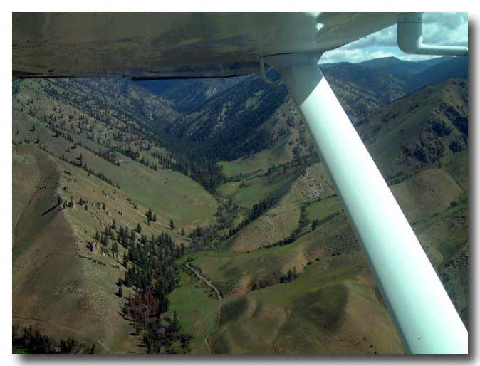
 View
of Cabin Creek to the north. There is a slight curve to the right
from runway 2 to the approach end of runway 20. Land on runway 2,
depart from runway 20. If the wind conditions do no allow this, wait
until conditions improve.
View
of Cabin Creek to the north. There is a slight curve to the right
from runway 2 to the approach end of runway 20. Land on runway 2,
depart from runway 20. If the wind conditions do no allow this, wait
until conditions improve.
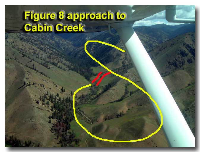
Note: There are two pine trees on the ridge that can be used for proper positioning at the desired approach altitude for runway alignment.


View down Cabin Creek toward the south. Fly up the right side of the Creek (left side of the picture), make a left turn and fly back to the approach end of runway 20. This "figure 8" procedure places you on a right-traffic downwind for runway 2.

 Fly
over the airstrip and check for traffic prior to making a commitment
to land.
Fly
over the airstrip and check for traffic prior to making a commitment
to land.
The turn around area at the end of runway 20 is visible here on the lower right side of the photo. The photo is taken facing toward the southwest.
 Airstrip located about 7 miles west of Soldier Bar airstrip on Big Creek. Shows parking area to the right of runway 20 (facing north). |
 Right base turn to final. Note opening in pine trees than are used to line up with the runway. |
 Aiming between the pine trees for correct runway alignment. |
 Final approach with proper runway alignment. |
 Final approach for runway 2. This is a one-way strip ... NO GO-AROUND. Elevation 4,200 feet. |
 Final-er approach to runway 2. |
 Final-est approach to runway 2. |
 On the runway (runway 2). Land ONLY on runway 2. Depart ONLY on runway 20. |
 Bring your own tie-downs if the airplane will be left unattended. |
 This appears to be a good tie-down area near the threshold of runway 20; however, this is a turn-around point. The tie-downs are on the east side near the approach end of runway 2. |
 Turn-around area looking at terrain to south-southwest. |
 Runway 20. |
 Erosion strips (rubber dams) occur at regular intervals along the runway. |
 Erissa
showing the height of the erosion strip. Erissa
showing the height of the erosion strip. |
 Erissa
demonstrating the stiffness of the erosion strip. Erissa
demonstrating the stiffness of the erosion strip. |
 Erosion strips with shadows may appear to make the runway unusable for landing. |
 Aligned for takeoff on runway 20 using a Cessna 172 (180-hp) with two passengers and baggage at 85ºF. |
 If in doubt, walk the strip and mark the half-way point. |
 Runway length 1,700 feet, width 40 feet. |
 Use rule of thumb - if 70% of takeoff speed is obtained by half-way point, continue the takeoff. |
 Left turn into Big Creek Canyon (east bound). Rule of thumb doesn't guarantee terrain clearance, only takeoff. |
|